

Boundary Surveys and Mapping
Boundary Survey
A boundary survey is a professional surveyor’s opinion as to the locations of your property lines, based on your deed and other available title information. Boundary determinations are based on long established and accepted principles. We prefer that our clients provide us with a copy of their title insurance policy or pay a title company to provide a preliminary title report containing a title insurable legal description of your property.
Parcel Map
The term parcel map refers to the process of dividing property into four or fewer parcels (with some exceptions) for purposes of "sale, lease, or finance." The most common application is that an individual wishes to divide their property for sale.
The parcel map process has become complex over the years. An early evaluation by our firm is highly recommended. A review begins by checking the City or County zoning to make sure that a land division is theoretically possible. In addition to the basic zoning defining the minimum parcel size and frontage requirements, every City and County has a laundry list of additional application requirements and land division criteria.
Aerial Surveys
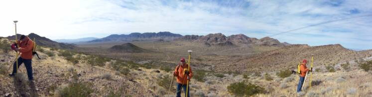
Our firm can work in conjunction with an aerial surveying company to provide aerial topography of properties. Often this is the most economical way to obtain detailed topographic information over large acreages. Whenever topographic mapping is needed on parcels larger than about 5 acres, aerial topography starts to become more economical. On large acreages, aerial surveying can be a fraction of the cost of ground topographic surveying.
Typical Procedures:
We typically seek proposals from aerial surveying companies and select a company that we have worked with before that has a demonstrated track record for performance, price, and accuracy. The general procedure for aerial mapping is as follows:
Our firm lays out targets or panels on the ground in locations specified by the aerial surveyor. These appear on the ground as a large white “X”s that are large enough to be visible in aerial photos.
We survey the relative locations of these panels and provide their horizontal and vertical coordinates to the aerial surveying company. Our work is completed using conventional surveying equipment or with survey grade global positioning systems.
The aerial surveyor actually flies over the property, taking a series of black and white photos with a large format aerial camera. Color photos can be obtained as an option, too. Using our panel information and the photos, the aerial photographer uses special photogrammetry equipment to compile topographic mapping showing contours, visible improvements, and foliage limits.
The aerial surveyor typically provides their product in both hard copy and digital form. The digital format is compatible with standard AutoCAD drafting software. We usually work with this product to add additional information as necessary, like approximate or accurately determined property boundaries.
Servicing : Nevada : Arizona : Utah : California